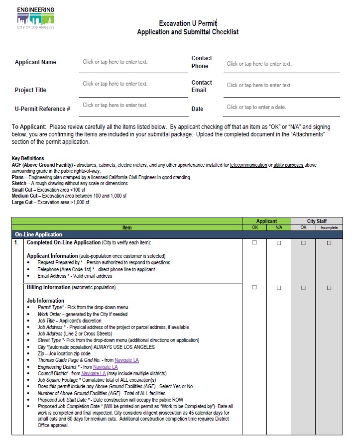
BOE staff have created an Excavation U Permit Checklist that Applicants can use to assist them in applying for a U- Permit.

ON-LINE EXCAVATION U PERMIT APPLICATION
New or Existing Customer Verification
The on-line application process is 100% the applicant’s responsibility to complete. City staff can advise the applicant on how to establish themselves as a “New Customer”. If the Applicant is already in the system, they would select their name from the “List of Customers” menu.
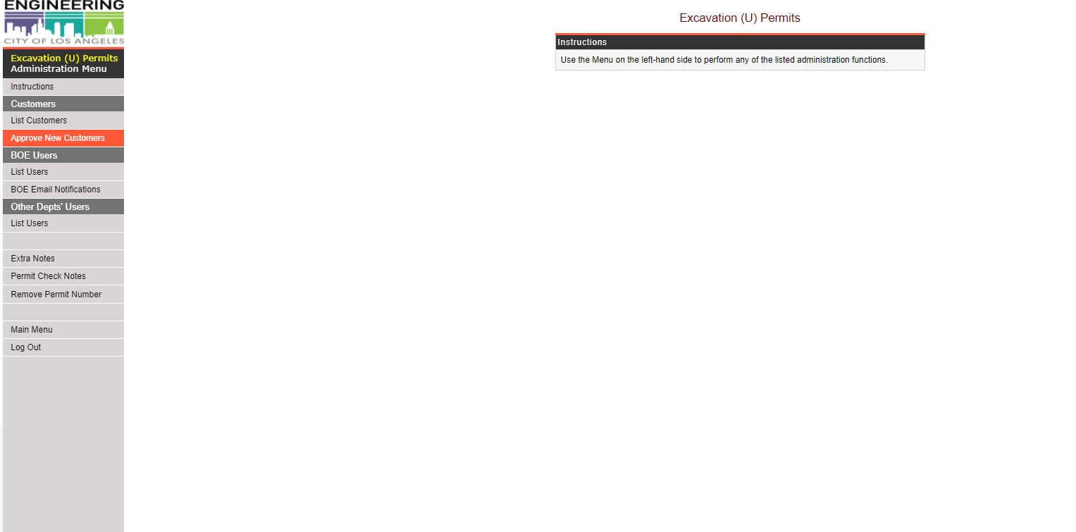
Once a new Customer is created, an email is sent to the U Permit Supervisor for approval or denial.
- U-Permit Supervisor to “Approve New Customer”

- Click on the Customer Name

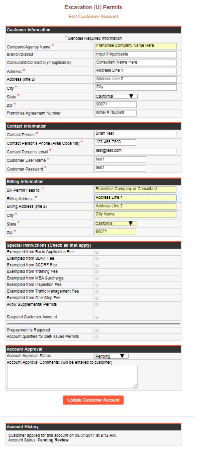
- Review “Customer Information”

- Confirm the Company/Agency Name is actually the Franchises Company name
- If the Applicant is a Consultant and has entered their own name), move this to the Consultant/Contractor Name
- Franchise Agreement #: Enter the Franchise Agreement number if known. If a consultant is the applicant, proof from the Franchise Company (on their letterhead) needs to be submitted stating the consultant is an authorized agent and can act on their behalf. This document should be submitted with the application.
- Review “Contact Information” for completeness (this is the only person that will received automatic notifications from the system)
- Review “Billing Information” for completeness
- Under Special Instructions
- These are left blank during the AGF Application process but are completed once the application is approved and moved into the Excavation “U” Permit process
- Account Approval
- Account Approval Status: Select the appropriate status
- Pending – Requested information has been requested but not received
- Denied – Incomplete information, non-responsive to request for additional information, or duplicate “New Customer”
- Approved – all applicable information has been received
- Account Approval Comments
- Insert any comments you want the Applicant to receive.
- Account Approval Status: Select the appropriate status
Excavation U Permit Processing
- From the main menu select the “View Unprocessed” button on the left. This is where Excavation U Permit Staff find new pending permit applications. These are listed in reverse chorological order (oldest to newest)
- Select the oldest open application for processing.
At the top of the screen, confirm whether or not a work order needs to be immediately opened.

- >1000 SF - Any application with a job square footage
- >1,000 sf requires a work order to be opened.
- ≤1000 SF – No work order is required and processing starts
- Go to Navigate LA and confirm the following layer are visible (“on”). These are not all the layers that can be seen. Some of the layers that will need to be enabled for permit processing are:
- Metro Bus and Metro Rail –> TCTMC Streets of Significance (Construction Impacted Streets) - Streets that are listed as TCTMC Streets of Significance require review and recommendations from the Transportation Construction Traffic Management Committee (TCTMC) before the permit is issued.
- Street Information –> Restricted Area –> Streetcar - Displays the Los Angeles Streetcar Project layer. No new facilities will be allowed within the proposed alignment of the streetcar facilities without prior approval of the Bureau of Engineering Streetcar Division. Further information for the streetcar can be found at http://streetcar.la/.
- Metro Bus and Metro Rail –> Metro Transit Projects - Displays current metro construction projects, any proposed excavation must be approved by Metro to ensure no conflicts with planned construction.
- Street Information –> TBM State Highways - State Highways are owned and maintained by CalTrans and a Caltrans permit is required for any work on a State Highway. The City of Los Angeles does not issue permits for any work located on a State Highway.
- Bureau of Street Services –> One-Year Moratorium Streets - Displays streets that have been paved within the last 365 days and are subject to an excavation moratorium.
- Bureau of Street Services –> Street Resurfacing Projects - Displays recent and planed street resurfacing projects performed by the Bureau of Street Services. This layer will assist in the determination of current and upcoming street moratoriums.
- City Planning Department –> Historic Preservation Overlay Zone - Historic Preservation Overlay Zones are areas of the city designated as having historical significance. Any proposed excavation in an HPOZ requires approval from the city planning department.
- City Planning Department –> Historic-Cultural Monuments - Historic-Cultural Monuments are areas of historic significance, as designated by the City, State, or Federal government. Proposed excavation in Historic-Cultural monuments requires approval by the Office of Historic Preservation.
- Recreation and Parks Department - A small number of medians in the city are actually owned and controlled by the Recreation and Parks Department. Any proposed work in these locations will not be granted a permit by BOE, but by the Recreation and Parks Department.
- Sewer Information - Contains various layers that show sewer structures, wyes, pipes, laterals, and other information related to the city sewer system.
- Stormwater Information - Contains layers that show storm pipe and storm drain locations and other information related to the city stormwater system.
- BOE Permits –> U-Permits - Displays the geocoding of recently issued U-permits that may not be included in the substructure map.
- BOE Permits –> Above Ground Facilities - Displays the geocoding of recently issued AGF-permits that may not be included in the substructure map.
- Maps and Indices –> Substructure Map Index - This layer will show the location and identification number of substructure maps for the corresponding portion of the city.
- Boundaries –> Bureau of Engineering Districts - Displays the boundaries of the city’s Engineering Districts
- Boundaries –> Council Districts - Displays the boundaries of the city’s Council Districts
Other layers may be required depending on the location and scope of the proposed excavation.
***Major Special Events such as the LA Marathon and Winter Holiday Moratorium will need to have filters enabled when work may conflict with them***
- BOE staff to confirm the following information within NavigateLA:
- Permit application has been submitted to the correct District office.
- Project location is within the “Streets of Significance” for TCTMC. If not, confirm if a work site traffic control plan is required.
- Whether or not the project location in under any construction and/or holiday moratorium. If there is a reference to a Resurfacing or Slurry Seal you need to obtain the Resurfacing Number and contact Bureau of Street Services (BSS) to get approval prior to issuing the permit.
- If the Applicant wishes to construct during a Holiday Moratorium, they will need to request a Holiday Moratorium Exemption with the Holiday Moratorium Exemption Request Template. Additional instructions on how to process this request can be found in this manual in "Other BOE Processes/Permits, Holiday Moratorium Exemption Procedures"
- Any parking meter sensors
- Any historic-cultural monuments
- If historic preservation overlay zone district exists
- Project location is within the Streetcar Project area
- Work hours for construction do not include peak hours, overnight, or weekends. Overnight work required Police Commission approval. Weekend work may require overtime work by City staff.
- Go to Google Maps Street View and do the following:
- Check for any conflicts with existing trees
- Verify the existing pavement type
- If the scope of work is within Metro Railways, plans will be sent to applicable railroad company, and once conceptual approval is given the Final U-permit will have the following conditions:
- R/W permit (from operating company of Rail Road or Metro, if applicable) be obtained prior to construction, and
- License agreement (if Metro is the owner) be obtained during construction
- BSL shall provide written approval for installations in an area of street between the face of an existing or future curb and four feet back of such curb face (LAMC 62.03). In addition, if the Applicant wishes to colocate on a BSL structure, BSL Colocation Guidelines must be followed.
- Perform a review based on and including what is listed on the U-Permit Plan/Sketch Checklist. Please note that small cuts (1-99 sf) only require the applicant to submit a sketch, not stamped engineering plans. For medium cuts (100-1,000 sf) and for large cuts (>1,000 sf) stamped engineering plans are required.
Per Ordinance #185818 - SDRF Fee Ordinance (effective 12/06/18), "Any excavation on a concrete street, full slab replacement is required in lieu of paying the SDRF." Concrete “slab”, or “panel” shall be defined as the area of concrete outlined by the nearest original construction / control / expansion joints. Therefore, when a concrete street is cut, concrete is to be removed and replaced to the nearest original construction joints. Full concrete slab/panel removal/ replacement is required, however, in areas where distinct slabs/panels do not exist, a minimum 150 SF rectangular shaped panel shall be removed and replaced.
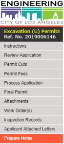
While performing the review using the checklist, BOE Staff will also compare what is provided on the sketch/plans with the information that was entered into the on-line application. BOE staff should check all items, especially the asterisked (*) items, including:- Select Review Application on the left main menu
- Verify the “Job Address (Line 2) or Cross Street” has been entered and is correct. This is important since many streets have N, S, E, W.
- Confirm the proper “Street Type” (caution, applicants check “Local Street” (this permit is cheaper)
- Confirm the correct Engineering District (also done at Navigate LA)
- Review the “Work Description” to confirm if the description matched what is shown on the plans. If it’s not correct, the applicant is notified to make the correction.
- Confirm the square footage in the Street Damage Restoration Fees grid
- Review for accuracy the field called “Please Type the Locations of Cuts using the following format:”
- Confirm the “Proposed Job Start Date” and “Proposed Job Completion Date” are accurate based on the applicant’s information. If the applicant changes the proposed dates, make sure this change is made here and in PWRS (see this section) to verify potential work conflicts.
- Confirm the Council District(s) field has been entered properly.
- Under “Backfill Type”, confirm the appropriate type is checked
- Under “Backfill Remarks”, enter the applicable notes from the U Permit Notes (Word document) on the Q Drive
- Under the “Permit Processing” grid, City staff can enter any information under the BOE Internal Remarks, City Staff to enter any necessary information.
- Check the Lock Application box once the application is reviewed and received. This locks the applicant out from making revisions
- Check the Assign Permit Only if a permit number is needed for cashiering. The permit has not been issued.
- Check the box in the “This is a no-fee permit (Waiver Fees)” only if there is a legal reason to do so. A legal reason is issued though a Council Action. If this box is checked do the following:
- Insert the Council File # and date in the BOE Internal Remarks field on this screen
- Insert the Council File # and date in the Prepare Notes (left menu), Prepare Extra Notes, the last box on the page
- Check the box in the “This is for a water-blowout” if applicable.
- Click Update
Permit Cuts
The Permit Cuts section of the application replaces the former Geocoder as well as integrates many of the other functions of the U Permit. The Permit Cuts section of the application indicates the cut locations and dimensions on a map, calculates SDRF, and automatically populates many fields in the U-Permit Application including Council District, Backfill Type, and Surface Type.
Applicants can find additional instructions about how to enter permit cuts by reviewing the Permit Cut guidelines document. These guidelines can also be reviewed by going through the U Permit Application.
Permit Fees
- Click on Permit Fees on the left menu
- Insert the number of hours spent on the permit application in the “U-Permit Special Eng Fee” box
- If applicable, insert the numbers of hours in the “BCA Special Inspection Fee” field
- Insert the number of days and lanes to be closed (based on the approved TCTMC letter) in the “Const Mgmt Traffic Fee” field
- Click Update Fees
Paid Order or Betterments (LADWP Permits ONLY)
Paid Order – A Paid Order application is a LADWP customer requested service. The customer is responsible for paying the City the SDRF Fee, the administration fee, plus 3% or $1 surcharge (whichever is greater). A Paid Order must be paid by the customer before the permit is issued.
Betterment – A Betterment application is a LAWDP betterment/improvement project paid by LADWP. SDRF fees do NOT have to be paid before the permit is issued.
Process Application
If there are corrections that need to be made to the application, sketch or plans, the customer is notified via the on-line system. In order to notify the applicant of correction, the following must be done.
- In the Process Box at the top of the page, change the “Permit Status” to one of the following:
- Cancelled – Generally done by the City, but the Customer does have the authority to cancel. If the City does this, they would request an email or letter and once received change the status to cancelled
- In the status comment box enter “Cancelled by (customer) on (date), see attached cancellation email/letter.
- Denied – Generally not used
- Incomplete – This means there is missing information or revisions are needed.
- In the Processing “Status Comment” box enter the comments about what is missing or needs revision on the application and/or the sketch
- In the “Incomplete Application (Reasons)” grid, select all the “Category” reasons for the incomplete application
- Pending SDRF Fee Payment – This means the applicant has not paid the SDRF fee. Once the SDRF fee is paid, the status would be modified
- Resubmitted
- Cancelled – Generally done by the City, but the Customer does have the authority to cancel. If the City does this, they would request an email or letter and once received change the status to cancelled
Final Permit
Selecting this from the left menu will prepare a PDF of the final permit.
Attachments
The attachments page is the place where both the applicant and City staff can upload documents. These documents can be letters of approval, plan sheets, sketches, photos, or any other document/file related to the permit application.
Finalizing attachments will signal that they have been reviewed and approved for the final permit. Attachments that should be added include:
- BOE approved plans
- TCTMC approval
- BSL approval
- TCP approval
- Streetcar approval
- UFD approval
- Structural calculations (E-permit shoring approval)
- SDRF calculations
- Cancellation requests
- Plan revisions
- PWRS maps and reports
Work Order(s)
A work order allows time spent by city employees to be charged directly to a permit application. A work order is required if
- The total square footage of a project is greater than or equal to 1000 ft².
- The customer is paying for expedited review.
- The project requires work to be performed outside of standard hours (night work or weekends, usually for Inspection).
- Other sections/divisions within the Bureau of Engineering, such as the Excavation E (shoring) or Standards Group (materials placed in the public right-of-way like vault covers) needs to review the plans.
When opening the work plan, do the following:
- Select Work Order of the left menu
- Select Request Opening a Regular Work Order (UR)
- Insert the Geocode information in the Permit Title field
- Insert the Geocode information in the Report Title field
- Insert the applicable Council District
- If the customer requires City Staff overtime (must be requested in writing), a UT work order is also opened
- Requires additional supervisory approval
- Deposit of $2,500 is required to be paid at the time of request
- For inspection, insert “76” which is the code for Bureau of Contract Administration on the Other Departments Field. Other department codes as needed include LADOT (94), Street Lighting (84), Street Services (86), Sanitation (82).
- Click assign work order
- Print the work order
- Attach the deposit check to the printed work order
- Give to clerical staff for depositing
- Clerical staff return the work order and Excavation U Permit Staff scan the work order and email to the applicant
Closing a Work Order
- Complete the Project Closeout Form (currently housed on the Central Div. Q: Drive under AGF/Work Order Closing Notices) and save it (WO #_City Reference #). See the sample.
- Get appropriate sign-off from the Civil Engineer or District Engineer to sign off
- Make a copy and put in the hard copy file
- Send the completed form to the Work Order Unit in the Administrative Services Division via City Gray mail.
Inspection Records
BCA Staff to enter inspection information in this section.
Applicant Attached Letters
Section provides the Applicant with a list of the various types of letters that may  be required from other City Departments.
Prepare Notes
The prepare notes section allows the application reviewer to add additional conditions and instructions to the permit.
- Prepare Extra Notes will allows comments and conditions to be added to the permit.
- Prepare Traffic Control Conditions ensures traffic control conditions are added to the permit. Always check the first three and update the permit.
- Prepare Notifications List, Prepare Special Conditions, and Prepare Traffic Committee Letter are for use by TCTMC. BOE staff generally do not use these.
Credit Card Receipt
If the Applicant pays with a credit card, BOE staff will be able to generate a receipt from this section. Generally, utility companies are invoiced on a monthly basis by the Office of Accounting, however, in some instances, like a Paid Order, the Customer of the utility company is required to pay the SDRF and SDRF Admin. fee.
Applicant will be subject to the City's credit card transaction fee (CF 18-0600-S159).
Public Way Reservation System (PWRS)
PWRS (LAMC 62.61.1) is a system that pulls information from NavigateLA and shows all activities in the public right-of-way in a report and map format with the goal of improving coordination of construction activities and other encroachments. BOE Staff should follow the PWRS Guidelines and provide the Applicant/Permittee with the report(s) to coordinate any potential conflicts. This action needs to be done directly preceding issuing the permit to avoid conflicts. If done too far in advance, there is a potential for new activities to be added to the system after the initial coordination.
Record History
Select this option from the left menu. This is a listing of when and who has modified the permit. There is no information to enter on this screen
Streets Impacted by Metro Line Projects
This menu selection is currently being updated to reflect active Metro projects and is pending an update by the City's Metro Transit Group. This section will show BOE staff and the Applicant if the area of the proposed project is subject to TCTMC.
AS-BUILT PLAN PROCESSING
In practice, As-Built drawings should be submitted to the District office having permit jurisdiction over the area in which the work was performed. City staff will compare the As-Builts submitted by the applicant with any approved changes that took place during construction. As-Built plans should be saved with the original plans. All conditions should be documented and incorporated into the City’s Substructure Maps.
LAMC Section 62.03(e) requires any “person owning, using, controlling or having an interest in any subsurface installation, other than a service connection, in any public street shall file with the City Engineer within 60 days after the completing of such installation, a corrected set of maps or atlas sheets showing the installation. Such map shall be drawn to a scale of not more than 200 feet to the inch.”
In the event such subsurface installation is for the purpose of carrying an unstable substance, as-built plans and profiles, showing the location, depth and size of the completed installation, in a manner acceptable to the City Engineer, shall also be submitted within said 60-day period.
Whenever such subsurface installation in a public street or sidewalk is abandoned or the use thereof is discontinued, the person owning, using, controlling or having an interest therein shall, within 60 days after such abandonment, file with the City Engineer a map showing in detail the location of the abandoned installation.
In addition, LAMC 62.02(c)1 states plans are required for any excavation made or facility installed and shall be located in strict conformance with the location shown on the plan.
EMERGENCY REPAIRS
The definition of “Emergency Work” as defined by LAMC 62.00 is defined as "immediate and unplanned action that must be taken to alleviate a hazardous condition, which represents an immediate threat to life, health, safety, or property. Emergency Work includes, but is not limited to, efforts to effect the restoration of interrupted utility services (electrical, water, gas, wastewater, and telecommunications)."
LAMC 62.02(a)6 defines when a permittee is required to apply for a permit in an emergency. All normal permit application requirements must still be met.
“Emergencies. Nothing in this section shall be construed to prevent any agency, entity or utility covered under the provisions of this Ordinance or any person or department or officer of this City who is maintaining an installation in a street by virtue of any law, ordinance franchise, or permit from making such excavations as may be necessary when such necessity arises from emergency conditions, provided that the person, department, or officer making such excavation shall apply for a permit therefor on the next regular business day following the day on which such excavation was commenced and provided that the agency, entity, utility, department or officer of this City provide supporting documentation confirming the nature and scope of the work required and verifiable information related to the event(s), actions, inactions or proximate causes of the required emergency excavation.”
Comments