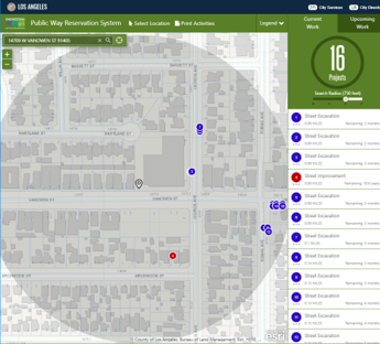
Public Way Reservation System (PWRS)
 Per LAMC 62.61.1 , PWRS is the place where all activities in the public right-of-way are shown in a report and map format with the goal of improving coordination of construction activities and other encroachments, reducing related effects on businesses and residents and minimizing the loss of traffic capacity resulting from construction or maintenance (including rail, utility, private development, street improvement, street maintenance, location filming and still photo shoots), or any other activity within the street.
This action needs to be done directly preceding issuing the permit to avoid conflicts. If done too far in advance, there is a potential for new activities to be added to the system after the initial coordination.
- Click on the "Public Way Reservation System" button (location on the top ribbon in the U-Permit application and on the left menu on other permit applications)
- If geocoding has already taken place, the job address should automatically populate in the location search bar. Otherwise, enter the job address in the location search bar
Note: By default, the system displays current work, but also has the capacity of displaying upcoming work. The view selected depends on the proposed construction dates and may require that both current and upcoming work activities be coordinated. - Select a radius from the search radius to review all the reservations with that buffer.
- Click on "Print Activities" (also known as the conflict report) located in the top ribbon.
- Download/Save the report(s) and print the map(s) to PDF
- Upload the report(s) and map(s) to the permit application system
Inform the Customer about the potential conflicts and that the report(s) are available within the system. Customer must coordinate any potential conflicts that are noted within the report(s)
Comments