Authority and Procedures
Background
History of the Subdivision Map Act
With the enactment of the first map act near the turn of the century, the State of California began regulating the recording of subdivisions and the conveying of subdivided lands. Until 1929, there was no effective control of filing of subdivision maps in the State of California. The coordination of land development by subdivision with the overall comprehensive community development was nonexistent.
As a result, the Map Filing Act of 1929 was enacted, and was superseded by what is currently known as the State Subdivision Map Act. The Subdivision Map Act is contained in California Government Code Section 66410, et. seq. It enables cities and counties to pass ordinances regulating subdivisions so an orderly and proper development expressing the needs and goals of the community can be achieved. The Subdivision regulations constitute one of the major administrative tools for developing land in harmony with the general plan.
LGD staff should be aware that laws governing the sale of subdivided lands, known as the California Real Estate Law, enacted in 1933, is still administered by the State Real Estate Commissioner. The basic objective is to protect the purchasers of property in new subdivisions from fraud, misrepresentation, and deceit in the marketing of subdivided lots and air space in the State of California, specifically as it relates to the sale of condominiums. Most subdivisions cannot be offered for sale in California until the Commissioner has issued a subdivision public report.
Division of Land Regulations - Tracts
The Division of Land Regulations for tract maps is contained in LAMC Chapter 1, Article 7, Section 17 (multiple sections). The list below includes some of the major features of Article 7.
- Designation of the Director of Planning as the Advisory Agency and prescribing its authority and duties (Additional information can be found in the Advisory Agency Section of this document). (LAMC 17.03)
- Establishment of the composition of the Subdivision Committee, which includes the City Engineer. (LAMC 17.04)
- Establishment of procedures and design standards for tentative and final tract maps. (LAMC 17.05)
- Establishment of design standards for dedication and improvements of streets, alleys, easements, and other engineering requirements. (LAMC 17.05.D-G)
- Coordination of the requirements for subdivisions in concert with the Grading Regulations, also established in 1962. (LAMC 17.05.L)
- Establishment of special standards for lots created under subdivisions, i.e., H-hillside zoning, lot averaging, minimum lot widths in commercial zones. (LAMC 17.05.H)
- Establishment of authority and payments for drainage districts and Recreation and Park Fees. (LAMC 17.05.P-Q)
- Protected Tree Regulations (LAMC 17.05.R)
- Establishment of implementation requirements for special specific plans such as the Mulholland Scenic Parkway and the Valley Circle - Plummer Street Scenic Corridor (Specific Plans can be found at the City Planning website) (LAMC 17.05.S-T)
- Preliminary Soils Report, prepared by a licensed Civil Engineer, may be required with the tentative map of any subdivision unless waived by the Advisory Agency. (LAMC 17.05.U)
Division of Land Maps (Lot Splits)
On July 30, 1962, the City of Los Angeles Lot Split Ordinance became effective. Since tract maps were required for divisions of five or more parcels, this ordinance provided for land divisions of four or less parcels. The City required dedications and improvements and generally monitored and controlled the division of land. When all of the conditions of approval were met, an official Division of Land Map was certified by the Deputy Advisory Agency. After certification, sale, lease and other conveyances by metes and bounds descriptions were permitted over the parcels.
The certified maps were not recorded, but were stored in the Division of Land files maintained by the Planning Department, City Clerk, City Engineer's Office and the Department of Building and Safety.
The Lot Split Ordinance was superseded on September 20, 1965, by the Parcel Map Regulations.
Division of Land Regulations - Parcel
In 1965, the State of California passed legislation amending the Subdivision Map Act to enable the division of land, generally for four or less parcels to be permitted under parcel maps. At the same time, the City of Los Angeles passed its Parcel Map Regulations under LAMC 17.50.
Condominiums
Originally created in 1963, the California Condominium Law was enacted. Currently, Condominiums are defined as a "common Interest Development" and can be found under Section 4000, et seq., of the California Civil Code. Section 11535 of the California Business and Professions Code, the Subdivision Map Act at that time, amended the definition of subdivision to include condominiums (condos) of five or more units. In 1975, the Subdivision Map Act was moved to the Government Code and redefined a subdivision as any division of a parcel. This means that a two-lot division of land or a two-unit condo constitutes a subdivision. A tract map may be required for five or more condo units. However, if the number of lots or condo units being created is four or less, a parcel map may be utilized.
The City of Los Angeles has chosen to limit its responsibility for condominium subdivision maps to the plat of the surface of the land. The division of air space and the administration therefore is regulated under the Subdivided Lands Act and enforced by the California Department of Real Estate.
Condominium is defined in Section 4125 of the California Civil Code as an estate in real property consisting of an undivided interest in common in a portion of a parcel of real property together with a separate interest in space in a residential, industrial or commercial building on such real property, such as an apartment, office or store. A condominium may include, in addition, a separate interest in other portions of such real property.
The condominium concept recognizes air apace as real property, thereby enabling rights established within a volume of air space to be equivalent to those rights traditionally established on a plat of the surface of the land, i.e., ownership, equity, taxes, leaseholds, rentals, etc. Condominiums cover not only residential development, but also commercial, agricultural and industrial developments.
Conceptually, residential condominiums should have strong demarcations of units, providing as much individualism (like single family dwellings) as possible. Double walls between units, acoustical treatment, individual utility meters, individual accesses, etc., serve to accomplish this. The land and the public areas of the building are owned as undivided interests by all owners.
Not long after the enactment of the Condominium Law, developers began to develop not only new condo units but converted existing apartments into condominiums.
The Condo Conversion Ordinance (Ordinance 153024) was first enacted in the City of Los Angeles in 1978. It provides, in part, that all requirements under subdivision proceedings be met before a condo conversion can be approved. The recording of a subdivision map constitutes approval by the City of the development as a condo conversion project. Thereafter, as in other subdivisions, many more procedural steps are required by the State Real Estate Commissioner before the condo units can be sold.
Tenancy in Common/Tenants in Common (TIC)
Tenancy in Common refers to arrangements under which two or more people co-own a parcel of real estate without a “right of survivorship”. This type of co-ownership allows each co-owner to choose who will inherit her ownership interest upon death. TIC owners own percentages rather than particular units or apartments. The right of a particular owner to use a particular dwelling comes from a written contract signed by all co-owners (TIC Agreement), not from a deed, map or other document recorded in County records. The California Department of Real Estate has issued a TIC Guidelines. Currently, BOE staff have no involvement with this process.
TIC Versus Condominium
The difference between physical division of ownership in county records (like a condominium) and an unrecorded contract allocating usage rights (like a TIC) is significant from a regulatory standpoint. California appellate courts have recognized a distinction between recorded and unrecorded documents assigning usage rights, and this distinction means that local laws restricting or prohibiting the conversion of apartment buildings into legal subdivisions such as condominiums do not apply to the creation of a tenancy in common arrangements. TIC also doesn't require any filing or approval with local governmental agencies. TIC formation only requires the approval of the California Department of Real Estate if the property to be co-owned and occupied by the group contains five or more residential units.
Small Lot Subdivisions
In 1999, the City Council established the Housing Crisis Task Force in response to a severe affordable housing shortage. The task force recommended increasing the availability of affordable housing through innovative land use strategies, including the small lot program. Under this small lot program, the City would allow lot to be subdivides within existing multifamily and commercial zones to develop fee-simple, detached townhomes that would not be required to be part of a homeowner’s association. In addition to the housing crisis, the development/construction community showed concerns regarding construction defects in a condominium type development, so the City worked with the industry to identify a new form of housing type which minimized the impact of construction defects to only the area where the defect was present.
On December 16, 2004, the City Council passed Ordinance 176354 amending LAMC 12.03, 12.09, 12.21.1, 12.21 and 12.22 to permit detached for-sale small lot subdivisions in commercial and multi-family residential zones. City Planning has also established Small Lot Design Guidelines for development of small lot homes. The guidelines outline site organization and urban form, parking and driveways, building design and materials, and landscaping and access.
Private Streets
The Private Street Regulations contained in LAMC Section 18.00-18.12 et. seq. were added by Ordinance effective May 19, 1951.
Originally, many parcels were created with legal frontages on public streets without provisions for vehicular access over the frontages. In the early years, enforcement of the private street regulations was not consistent, and interpretations of the regulations were often confusing.
The City Attorney, on September 6, 1961, declared that whenever vehicular access to a parcel of land was not coincidental with the legal frontage, a private street approval from the City was required prior to issuance of a building permit.
Private street applications are usually filed to seek approval for access to an existing single parcel of land using a private road easement. The following is an overview of the private street application process.
- When a property owner applies for a Building Permit for a parcel that is NOT fronting a public street, LADBS will refer the Applicant to City Planning for a Private Street Determination
- If City Planning determines a Private Street Process is required, the following items apply:
- The Private Engineer or Land Surveyor obtains a private street number from the LA County Department of Public Works in the same manner that tract numbers are obtained (See "The Tentative Subdivision Map" Section of this document).
- The engineer or surveyor then prepares a map and makes an application to the City Planning Department.
- The map is processed in a manner similar to tentative tract maps (See "District Office Early Submittal Tract/Parcel Maps Expedited Processing" Section of this document).
- A hearing is held before the Advisory Agency who may approve or disapprove the private street with conditions.
- City Planning would issue a Letter of Determination, including appropriate conditions for the Applicant to comply with. City Planning is the agency that monitors the clearance of conditions (different than the Final Map Process)
- Once all conditions have been met, City Planning will notify the Department of Building & Safety to issue the building permit under the normal permit process (Clearance Summary Worksheet Process).
Under a private street application where a parcel or land is being divided into four or less parcels, a final parcel map shall also be required. Where five or more parcels are being created with private street access, a tentative and final tract map is usually required.
When a private street application is made for a legally created single parcel and no further division of land is proposed, a Final Parcel Map is not required. There is currently no City requirements that a private street map be recorded (the end product of the Private Street Process is document in "F above).
Private Streets -vs- Public Streets
On numerous occasions, approval of private streets in lieu of public streets are sought in Subdivisions. This occurs where homes are being developed proposing full privacy by utilizing a private street system for access, with guard gates at entrances.
The City Engineer's office does not object to private streets provided three basic criteria are met:
- The private street does not represent a circulating street needed to serve the community or the region, i.e., collector streets, highways.
- In General, private street improvements are constructed in accordance with the City Engineer's specifications for public streets, both in dimension and structural section (as shown in in the 2035 Mobility Plan). However, engineering judgement shall be used to determine if strict enforcement of public standards is necessary since the public will not use the street.
- The private street is to be maintained privately.
Private Road Easements
Private road easements, in themselves, do not entitle the easement owner the right to obtain building permits. (See Final Private Street Approval within this document. Also, see Private Street Variations). Private street approvals involve access over parcels owned by others. An easement for road purposes granting the right of vehicular ingress, egress, maintenance, and utilities is required.
LAMC 18.01 describes a private road easement as a parcel of land not dedicated as a public street over which a private easement for road purposes is proposed to be or has been granted to the owners of property contiguous or adjacent thereto which intersects or connects with a public street, or a private street; in each instance the instrument creating such easement shall be or shall have been duly recorded.Private Street Improvements
If a private street is created in conjunction with a Subdivision Tract or parcel map, BOE would normally apply public street standards to this type of private streets. However, for private streets created under LAMC 18.01 (would have a private street case Number such as PS 1200), engineering judgement would be utilized to determine the actual requirements for the roadway involved. Often, this roadway already existed and other property owners are using the roadway for ingress/egress which will make upgrading the roadway to public standards extremely difficult.
In certain cases, a minimum 20-foot roadway within a 24' easement with either a vee or crown section is permitted. Public facilities such as water, power and sewer lines may be permitted within dedicated public easements in the private street. All private streets are required to be posted with signs, delineating the name of the private street, if named, and designating that it is not dedicated for public use or maintained by the City. The reason for the City's insistence for public street standards and improvements on private streets is to protect future buyers, reduce maintenance costs, and provide for their acceptance as public streets should local community pressure demand it.
Private Street Maintenance and Enforcement
Per LAMC Chapter VI, Article 5, 65.00, all private streets shall be maintained by persons having ownership thereof and by the owners of property contiguous or adjacent thereto in such a manner that adequate access by vehicular traffic is provided at all times so that fire, police, health and sanitation, and public utility vehicles can serve the properties contiguous or adjacent thereto, and so that said vehicles will have adequate turning areas. The City has no responsibility for such maintenance.
Prior to January 6, 1971 (passing of Ordinance 141,406, now LAMC Chapter VI, Article 5, Section 65), there was no procedure for the enforcement of the maintenance of private streets or easements. LAMC 65.05 - LAMC 65.5 - Order to Repair – Persons Entitled to Copy provides for the Director of Street Maintenance (now called the Director of Street Services) to issue an order to correct the hazardous condition of any hazardous private street. The order shall include the following:
- The street address and legal description, sufficient for identification of the parcel or parcels constituting the private street.
- A brief statement specifying the defects causing the street to be a hazardous private street and their location.
- A statement of the work required to be done in order to correct said defects and place the street in a reasonable state of repair in light of its original construction and that no work shall be commenced without first obtaining a written permit pursuant to LAMC 62.106 - LAMC 62.111.
- The time in which the work required to be done must be commenced, which shall not be later than 60 days following the issuance of the order, and shall further specify a reasonable time within which the work shall be completed.
Final Private Street Approval
The final private street approval occurs when the City Planning Director determines that access is adequate, a private road easement has been duly recorded, and all conditions of the approval of the private street application have been met. The Planning Director then issues a clearance to LADBS for issuance of building permits.
Private Street Variations
Effective May 1, 2001, the Planning Director issued variances for Private Street Regulations in the form of General Variations Nos. 2001-1 and 2001-2, Community Driveways. These two standard polices modify the Private Street Regulations and the authority for these modifications is found in LAMC 18.12. These policies were developed in collaboration with the LADBS to clarify the number of lots which could be served by common driveways.
There are two policies.
- “Private Street Regulations, General Variation 2001-1”, applies to the use of common driveway facilities for single family residential uses. The revised policy will permit a common driveway to serve no more than two single family residential uses.
- “Private Street Regulations, General Variation 2001-2”, addresses the use of the community driveway for Industrial, Commercial, and Multi-Family Uses.
The parcels must be served with a roadway and easement not less than 15 feet wide and not over 300 feet in length from the nearest public street or approved private street. If the length of the private roadway is over 300 feet in length, an adequate turning area is required. The easement shall not serve more than two single-family dwellings and will be located entirely on the subject lots.
Upon verification of these requirements, LADBS can issue a building permit without further approval by the Planning Director.
Common Driveways (Community Driveway per LADBS) for Single Family Uses
General Variation 2001-1 applies to lots zoned RW-1 or more restrictive containing single-family residential uses except that both lots may be vacant. For other than single family properties, see the Private Street Variation Section of this document.
Pursuant to the authority vested in the Planning Director by provisions of LAMC 18.12, Chapter 1, Article 8, relating to the issuance of building permits for two existing lots, the Planning Director grants the following variation to permit common driveway facilities without further approval, subject to the following conditions:
- The lots are separate legal parcels of record prior to July 30, 1962, with required street frontage or are separate parcels or lots shown on a recorded Parcel Map or recorded Tract Map; or have recorded Certificate of Compliance; and
- The driveway shall not cross more than one lot and shall not serve more than two (2) existing single family residential lots; and
- The driveway within such easement is improved to a width in conformance with the Fire Department’s fire access standards as stated in LAMC 57.09.03, but in no event less than 20 feet; and
- Ingress and egress easements in the common driveway have been recorded in favor of the involved owners in a manner satisfactory to the Department of Building and Safety; and
- The unobstructed distance – from the ground to the sky – between buildings located on either side of said driveway is no less than 20 feet and otherwise meets all other setback and yard requirements of the LAMC.
This variation supersedes the previous General Variations dated February 1, 1996, March 28, 1974 and June 23, 1967.
Common Driveway for Industrial, Commercial and Multi-Family Uses
General Variation 2001-2 does not apply to lots zoned RW-1 or more restrictive containing single-family residential uses except that both lots may be vacant. See the Private Street Variation section of this document.
Pursuant to the authority vested in the Director of Planning by provisions of Section 18.12, Article 8, Chapter I of the Los Angeles Municipal Code, relating to the issuance of building permits for two existing lot, the Director grants the following variation to permit common driveway facilities without further approval by the Director of Planning, subject to the following conditions:
- The lots are separate legal parcels of record prior to July 30, 1962, with required street frontage or are separate parcels or lots shown on a recorded Parcel Map or recorded Tract Map; or have recorded Certificate of Compliance; and
- Notwithstanding LAMC 12.21-A. A driveway within such easement is permitted over one or more lots to serve another lot(s). The driveway shall be located and maintained on property which is in a more restrictive zone than that of the property on which the building(s) served is (are) located; except that where a lot is partly in the P Zone and partly a C or M Zone, any P Zone may be used. A driveway may also be located in a more restrictive zone than the zone of the lot where any of the building(s) is (are) located provided that the uses are permitted in the more restrictive zone; and
- The driveway within such easement is improved to a width in conformance with the Fire Department’s fire access standards as stated in LAMC 57.09.03(can not find these numbers) , but in no event less than 20 feet; and
- Ingress and egress easements in the common driveway have been recorded in favor of the involved owners in a manner satisfactory to the Department of Building and Safety
- The unobstructed distance – from the ground to the sky – between buildings located on either side of said driveway is no less than 20 feet and otherwise meets all other setback and yard requirements of the LAMC.
This variation supersedes the previous General Variations dated February 1, 1996, March 28, 1974 and June 23, 1967.
Subdivision Definition
Section 66424 of the California Government Code defines a subdivision as the division by any sub divider, of any unit or units of improved or unimproved land, or any portion thereof, shown on the latest county assessment roll as a unit or as contiguous units, for the purpose of sale, lease or financing, whether immediate or future, except for leases of agricultural land for agricultural purposes. Subdivision includes a condominium project, and in certain instances, a community apartment project or the conversion of five or more existing dwelling units to a stock cooperative.
Concept of Subdivisions (Tract Maps)
The general concept in processing tract maps in the City of Los Angeles is when the City permits a tract map to record, the subsequent development will experience minimal future obligations for public improvements, fees, and encumbrances. To accomplish this, all required public works (streets, sewers, drains, etc.) are provided within public easements at the subdivider’s expense and no additional work is anticipated. In some cases, the subdivider can shift the cost of the public improvements to the home buyers by creating a Mello-Roos Assessment District (See Mello-Roos Act and Special District Financing for additional information). In addition, other future fees, such as those for recreation and parks or sewer and drainage purposes will be paid, leaving as little burden as possible on future owners.
Before a final tract map can be recorded the following must take place:
- All outstanding assessment liens and taxes are paid
- All required public improvements are either installed or guaranteed to be installed
- All lots meet the area and width requirements of the zoning code
- All parties necessary to sign the final map have done so and have consented to the recordation of the tract map
- A survey is completed and monumentation of the tract boundaries is completed or guaranteed
The final product of a completed tract map should provide assurance to the ultimate purchaser that each lot or parcel being conveyed has undergone a full review by the City of Los Angeles. The purchaser should feel secure that, to the extent possible, all considerations for health, safety and welfare of the general public, as well as compliance with the provisions of local and State laws and the City's General Plan, have been satisfied.
Illegally Created Parcels
Unless a Division of Land Map has been approved, those lots created by metes and bounds descriptions under deeds recorded after July 30, 1962, the date of enactment of the City's Lot Split Ordinance, are deemed illegally created, even if they meet the zoning regulations.
Those lots similarly created between 1946 and July 29, 1962 are deemed legal lots provided they meet the zoning regulations in effect at the time of creation of the lots and otherwise met the definition of Lot under LAMC 12.03. Sales of parcels created in violation of the Subdivision Map Act are voidable by the purchaser within one year from the date of discovery of the violation.
Legalization of Parcels
Legalization of questionable or illegally created parcels can take place in numerous ways under City and State regulations. The methods include:
- Record a tract map or parcel map
- Record a Certificate of Compliance administered by City Planning
- Obtain a letter of verification by City Planning that the lot was legally created by deed prior to July 30, 1962, or prior to 1946 if the lot does not comply with the zoning
Reasons for Subdivision Maps
The main reasons for subdivision maps include:
- Division of Land: A tract or parcel map shall be required to divide any parcel of land. If there are five or more parcels being created, tract maps are required, with some exceptions (Section 66426 of the Subdivision Map Act).
- Facilitate Street Vacation: A tract or parcel map may be required in connection with City Council approval of a request to vacate street, alley or walk easements if it is determined a map would:
- Facilitate dedications and improvement of streets, alleys and other public rights of way.
- Provide a simple legal description to consolidate the vacated area with adjoining properties and to eliminate an existing difficult or complicated metes and bounds legal description.
- Verify legal access to applicants or owners of adjoining parcels, where vacation of a street would cause land locking, resulting in a need for a private street or subdivision approval.
- Reversion to Acreage and Merger: Sections 66499.11 to 66499.20, inclusive, of the California Government Code, outline the procedures and requirements relating to reversion to acreage of subdivided lots and the abandonment of public easements not shown on the final map. Section 66499.20.1 and 66499.20.2 of the California Government Code permits merging of subdivided lands and re-subdivision to be accomplished by a single map. The process is termed "merger".
Although the merger procedure does not specifically require it, findings by the legislative body should be made in the same manner as prescribed in the Reversion to Acreage Sections 66499.15 and 66499.16 and proper notification must be given by the Advisory Agency on the tentative map hearing. The Council's findings are necessary for the final map because public rights to easements are being relinquished. For a subdivision project in which the subdivision or the proposed street merger is an issue of controversy, LGD staff should recommend the Advisory Agency not approve the merger and accept the street vacation be processed for City Council approval.
Reversion to acreage or merger shall be effective upon recording the final map and shall also constitute abandonment of all streets and easements not shown on the map. The final map checker and district design office should exercise extreme care when reviewing final maps undergoing reversion to acreage or merger, to verify all needed public easements are shown on the map. - Zone Change: In many instances when a zone change is approved by the City, the requirement to file and record a Subdivision map is included in the conditions of approval. In some instances the development of the property would have normally required a subdivision map, such as a zone change to a single family zone to permit one larger parcel to be further subdivided. However, if a number of other situations exist which would make it desirable to have a subdivision over a particular parcel of land, a tract or parcel map will be required.
- Other Instances: In order to facilitate the following, maps can be utilized:
- Extensive sewer facilities are required (LAMC 64.11.2 provides for offsite sewers under tract map applications)
- Extensive and complicated dedications and improvements of public streets are required
- Extensive drainage facilities are needed
- Restriction or control of vehicular access is required
- The parcel is described by complicated metes and bounds descriptions and a simple description afforded by a new recorded map is deemed necessary
- A survey is necessary to properly define the parcel
- A proper tract layout study is needed to provide access to adjoining un-subdivided property
Policies
Streets Standards Committee
Per LAMC 17.05 - Design and Standards, the Streets Standards Committee is composed of the Director of Planning as Chairman, the City Engineer and the General Manager of the Department of Transportation. The Committee shall recommend to the Planning Commission the minimum widths of rights of way and roadway improvement standards for all classes of public and private streets and alleys. The present Standard Street Dimensions (Standard Plan S-470-1 - Standard Street Dimensions) was created by the Streets Standards Committee and was adopted by the Planning Commission in May 13, 1999.
Conform to General, Community, and Specific Plans
Each subdivision approved must contain a finding that it conforms to both the General, Community, and Specific Plans. It must conform to land use, zoning, circulation, drainage, housing and every other element of the General Plan and/or Specific Plan(s). In addition, any Specific Plans such as the Warner Ranch, Mulholland Scenic Parkway, etc., must be considered and the terms or conditions of subdivision approval must reflect the spirit and intent of the Specific Plans.
One example where elements of a Community Plan would impact development is Slope Density. In various hillside areas of the City with Minimum, Very Low and Low Density land use designations in the General Plan and wherever the average natural slope of a lot is 15% or more, Minimum Density Housing shall apply. Although the slope density regulations often involve the determination and calculation of natural slopes, the process is entirely within the jurisdiction of the City Planning Department. LGD staff should refer all questions on this issue from developers and private engineers to the City Planning.
City Engineer's Standards
All streets and highways (classified as Boulevards, Avenues, Collectors, and Locals) must conform in alignment and grade to the City Engineer's design specifications. The street widths should conform to Standard Plan S-470-1 - Standard Street Dimensions. The maximum grade for streets should be based on the criteria under the Street Design Manual, Sections E 321.1 and Section E 531.111. The horizontal alignments for all streets should be designed in accordance with the Street Design Manual, Part E.
Scope of Street Improvements
Where a proposed subdivision adjoins one side of an existing street, full dedication and improvement for at least one half the ultimate street width shall be required of the subdivision.
Widening of Existing Substandard Roadways
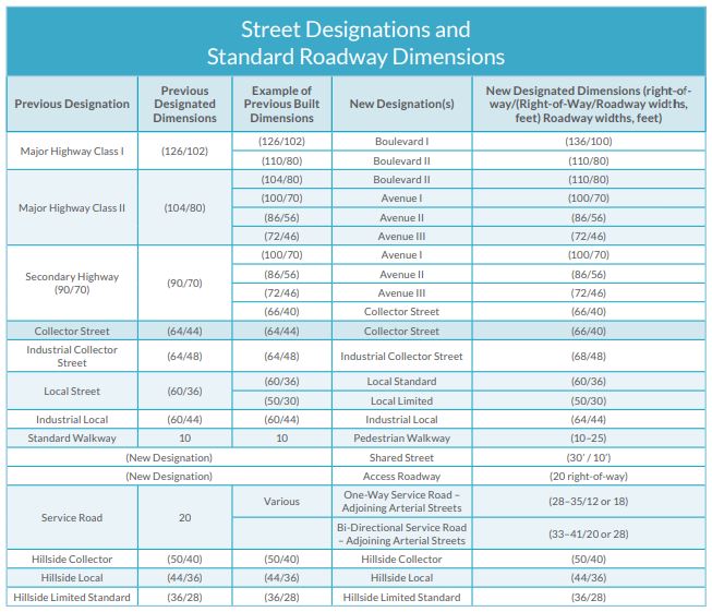
Street Designations and Standard Roadway Dimensions
Each of the City’s arterial streets included in the General Plan Circulation System Maps (found in the 2035 Mobility Plan) have been re-designated from the 1999 Transportation Element to reflect the new arterial types included in the Street Standard Plan S-470-1. S-470-1 includes five arterial road types (Boulevard I, II, Avenue I, II, III) whereas the previous S-470-0 had only three (Major Highway Class I, II, Secondary Highway). The expanded range of dimensions more accurately reflect the range of street dimensions that exist today and acknowledges there are many arterial streets that are, and should remain, narrower than their current designation would permit. In a majority of instances, today’s arterial streets have not yet been expanded to reflect the full dimension envisioned by the current designation, as physical changes to the roadway are not made until adjacent parcels are redeveloped.
Per the 2035 Mobility Plan, the following table is the street designations and standard roadway dimensions for all streets in the City of Los Angeles, unless modified by Specific Plans or other legislation.
Dedication and Improvement Requirements
Dedication should be required in accordance with the current standards in effect (Special Order 010-0900 and the Street Design Manual). Additional information regarding Highway Dedication Processing can be found in Administrative Requirements Section under 12.37 Highway Dedication Processing.
In the hillside terrain area, deviations from the standard required right of way widths may occur. The primary concern is whether the required roadway and right of way widths are determined to be sufficient to perform the minimum functions for the classification of the street being considered.
When an incremental roadway widening is determined to be necessary, Special Order 010-0900 and engineering judgement should be used on whether a physical widening of the roadway can be feasibly accomplished. If not, the possibility of an option for cash payment in lieu of construction can be explored (if approved by District Engineer or LGD Division Engineer) and the following considerations should be made for this determination:
- Probability of further land development in the block within 10 years
- Capital Improvement Projects or Assessment Projects covering the adjacent frontages within 5 years
- Drainage
- Existing buildings, terrain or other physical constraints would reduce the parkway width to less than 5 feet
- Condition of existing improvements
- Street frontage to be widened is sufficient for suitable transitions on both ends of the widening
- Street trees
- Traffic hazards created by incremental widening
- Any historical features
Certificate of Occupancy: Per Ordinance No. 165,081, the Department of Building and Safety will not issue the Certificate of Occupancy until LGD staff have confirmed all required public improvements have been completed. Per LAMC 91.109.3 - Issuance of Certificates. (Amended by Ord. No. 185,587, Eff. 7/16/18.) When required by LAMC 91.109.1, after the receipt and approval of the final inspection report from each of the divisions of the Department, and after the City Engineer has reported that all required public improvements have been completed, the Superintendent of Building shall issue a Certificate of Occupancy, without charge, to the owner of the building. Duplicates of the certificate may be secured upon the payment of the duplication fee required by ordinance.
Advisory Agency
Authority and Actions
Authority
The Los Angeles City Charter (rewritten in 2000) Section 553 allows the Planning Director to make investigations and reports on all proposed subdivisions of land. Administration of the provisions of the State Subdivision Map Act and the LAMC on land development in the City of Los Angeles is vested with Planning Director who is designated as the Advisory Agency. The Director appoints a Deputy Advisory Agency who is empowered to conduct public hearings on Subdivisions, make determinations and render decisions in behalf of the Director.
Actions by the Advisory Agency
The Advisory Agency conducts public hearings with the Subdivision Committee which makes recommendations on all tentative tract and private street maps and other matters before the Advisory Agency. The Advisory Agency conducts regular meetings and all such meetings are open to the public.
The Advisory Agency is required to approve, conditionally approve, or disapprove a tentative tract map application. The Advisory Agency must make a finding that the proposed subdivision is consistent with applicable general or specific plans. This means that provisions in the district plans and all other elements of the General Plan must be satisfied. He or she must also find that the tentative map satisfies the seven (7) findings in Section 66474.61 of the California Government Code (Subdivision Map Act). In addition, the provisions in the specific plan, i.e., zoning codes and ordinances, and other, special specific plans adopted by ordinance such as Warner Ranch, Mulholland Scenic Parkway, etc., must also be satisfied.
In making any such action, the Advisory Agency is authorized to include or omit in whole or in part the reports or recommendations of the City Engineer, except the Advisory Agency may not omit any mandatory requirements relating to public health or safety recommended by the City Engineer in the exercise of his/her duties prescribed by law. Before approving the omission of a report or recommendation made by the City Engineer, the Advisory Agency shall submit the matter to the members of the Subdivision Committee for consideration at a regular meeting. The Advisory Agency must certify the environmental assessment before acting on a tentative tract map. The environmental assessment can range from a general exemption to a full Environmental Impact Report.
The Advisory Agency must also make other findings including conformance with the Flood Hazard Management Specific Plan, California Water Code, etc.
Actions by the Advisory Agency are in writing so that proper documentation is available in the files. Initial tract approval letters by the Advisory Agency include, in part, the Standard Conditions S-1, S-2 and S-3 contained the Bureau of Engineering's Standard Conditions. (G. Vanergriff is updating these conditions as of 2/5/20)
Appeal of Advisory Agency Decision
The applicant can appeal a decision from the Advisory Agency to the City or Area Planning Commission and then to the City Council. This appeals process is totally administered by the City Planning Department. During the appeal process, BOE may be requested by City Planning to provide additional information on the case in question. Both the Area Planning Commission and/or the City Council can supersede the decision of the Advisory Agency. Actions by City or Area Planning Commission and ultimately the City Council, will be the final decision of the application.
Other Actions by the Advisory Agency
Extensions of Time
The initial approval of a tentative subdivision map is for a duration of 36 months. Additional extensions of time up to 6 years may be granted by the Advisory Agency. The final map must be submitted to the City Engineer for certification before the expiration of the time limit. The date of initial action on the tentative tract map can be other than the Advisory Agency's action date if there was an appeal to the City or Area Planning Commission, and further to City Council. The last action date will be the initiation of the first 36-month period.
Time extensions are granted by the Advisory Agency if such time extensions are requested in writing before the previous period expires. In the event of any confusion over the time limit, the Applicant should be referred to the Advisory Agency for an official determination.
Modifications
In general, no material changes to the conditions of approval shall be authorized without a prior Planning Department approval. If changes are originated from LGD, LGD staff will coordinate with Planning for the revision of project conditions. If changes are initiated from the Applicant and agreed upon by LGD, and:
- If the project requirements are specifically identified and listed in the Planning Department approval document, the Applicant shall be advised to initiate official revisions to the project conditions with Planning. LGD staff will submit a formal response back to City Planning when the revision is referred to LGD for comment. LGD staff will collect the appropriate fee to process the modification request per the BOE Standard Fee List. LGD shall not on its own modify any part of the project conditions during plan check or construction if those conditions are specifically listed and identified in the Letter of Determination (approval document).
- If the requirements are not specifically identified and a general condition such as "Dedicate and improve the street satisfactory to the City Engineer" is shown on the Planning approval document, LGD will prepare a revised report to Planning to document the revision, if necessary.
Tentative Tract Maps
After an initial action on a tentative map, any of the conditions may be modified, if approved by the Advisory Agency. The reasons for the modification can vary from hardship to a change in circumstances. The modification request and fee is submitted to the Planning Department and the request is referred to all involved departments for recommendations:
LGD will determine if the modification needs to be forwarded to the District office for consideration or comment.
Modifications to Recorded Final Tract or Parcel Maps
Section 66472.1 of the California Government Code (Subdivision Map Act) provides for amendments of recorded tract and parcel map conditions with a certificate of correction. LAMC Section 17.14 (Amended by Ordinance 164,845, Eff.6/17/89)enables the Advisory Agency to process requests to amend conditions of recorded tract and parcel maps. These requests will be handled by the Advisory Agency substantially in the same manner as modification requests, except that notification for the public hearing is mandatory, Section 66451.3 of the Subdivision Map Act. Merger of an existing public easement in general is not permissible under this amending of the final map process unless it is approved by Planning under special circumstances.
Subdivision Committee
The Subdivision Committee is composed of the following:
- City Engineer
- General Manager, Department of Building and Safety
- General Manager, Department of Transportation
- Chief Engineer of the Department of Fire
- General Manager, Department of General Services
- Chief Engineer and General Manager of the Department of Water and Power
- General Manager, Department of Recreation and Parks
- Director of the Bureau of Street Lighting
It is the duty of each Subdivision Committee Member to report on each Tentative Subdivision map application and to provide qualified representatives to weekly public hearings. These representatives should be fully empowered to act on behalf of their departments at the hearings.
City Engineer
The City Engineer has the responsibility of performing the required civil engineering necessary in the prosecution of work in the public right of way. The City Engineer is responsible for making an investigation, research, analysis and a formal engineering report on all tentative tract and parcel maps filed in the City of Los Angeles. The City Engineer appoints a list of representatives who are authorized to represent him or her at public hearings on subdivision matters. During these hearings, these representatives are expected to explain the City Engineer's formal report for each subdivision and answer questions that may come up during the public hearing. They are also authorized to negotiate, and on occasion, revise the formal recommendations if information not previously considered is deemed to be important.
At this time, LGD staff are performing this duty on behalf of the City Engineer.
Tentative Tract Reports
LGD is responsible for preparing comprehensive Engineering Reports on every new tentative tract map filed in the City of Los Angeles. These reports are submitted to the City Engineer for review and signature, and become a public record of the recommendations of the City Engineer.
The objectives of these reports is to establish consistent street standards and confirm public improvements are implemented. LGD staff will prepare these reports in a consistent and standard format.
Section 66452 et. seq. of the California Government Code (Subdivision Map Act), requires the Advisory Agency act on the tentative map within 50 days after the map has been filed, and that they shall approve, conditionally approve, or disapprove the map. The Subdivision Map Act further provides that the time limit for acting and reporting on the tentative map may be extended by mutual consent of the subdivider and governing body or advisory agency. If no action is taken within these time limits, the tentative map as filed shall be deemed to be approved, and it shall be the duty of the clerk of the governing body to certify the approval.
Per LAMC 17.06 - Tentative Map and Appeals (Los Angeles City Subdivision Ordinance) requires the City Engineer to report within 39 calendar days of the filing date of the tentative map or within such additional time as the Advisory Agency may approve. Currently, the 39 day time limit is based on the latest date of one of the following, but both must be received:
- Date LGD receives the referral from Planning
- Date that payment of the BOE processing fee was received
Prompt action is an important factor in the preparation of the City Engineer's Report. Delay by the City Engineer in reporting on the map can result in automatic approvals of subdivisions which could be unsatisfactory in many respects.
Function of the Land Development and GIS Division (LGD)
The function of LGD is primarily one of coordination, verification, and clearance of tract map conditions. Specific engineering and technical recommendations originate in the District offices. Consistent with the General Plan requirements, LGD is responsible for combining these recommendations into an integrated comprehensive report.
If any inconsistencies or discrepancies are discovered during the preparation of the report, or the engineer feels that certain changes are necessary after studying all available information, the matter should be discussed with the District office submitting the recommendation. If there is disagreement with between LGD and the District office, LGD staff should escalate the matter to a supervisory level.
Under no circumstances should LGD arbitrarily change the recommendations of other Divisions or Bureaus. LGD should respectfully communicate and collaborate with the involved Division or Bureau prior to finalization of the report. LGD's primary role in this process shall be one of coordination.
The Tentative Subdivision Map
A Registered Civil Engineer or Licensed Land Surveyor may prepare a tentative subdivision map. A tract number is first obtained from the County Engineer. The private engineer is allowed to utilize the tract number until either a final map is recorded or the number is forfeited due to passage of time with a lack of activity toward recordation or expiration after three years.
Early Submittal Tract / Parcel Map Expedited Process
This procedure describes the process and method for payment of fees to LGD for the early submittal of tentative tract/private street maps and preliminary parcel maps as performed at District Office Public Counter. This process is generally used because Applicant's want to speed up the process with Planning. Currently, Planning with not accept expedited applications unless the Applicant also requests and expedited BOE process.
In order to start an expedited process, the Applicant will be required to submit their package to LGD (tract map number must have been assigned by Planning) before Planning provides the package to LGD . By submitting packages directly to LGD 's Public Counter this will allow LGD to get an early start in the review of the application.
This procedure is MANDATORY for all “Expedited Processing Cases.” Applicants who elect to hand carry the submittal package to LGD must also pay LGD 's investigation and report fee per LAMC 19.02 - Filing Fess - Division of Land and Private Street Maps and Appeals and LAMC 61.16 (Expedited Permit Surcharge). Applicants will be given a “Proof of Payment” form as evidence the fee(s) was paid and the required materials were submitted. Partial submittals will NOT be accepted.
Public Counter Expedited Process Procedures (Expedited Process)
The below processes are specific to when an Applicant is to utilize an expedited process. The expedited process will require the Applicant to provide copies of many of the documents that would normally be provided by City Planning. BOE staff will check the Applicant’s submitted package for completeness prior to acceptance, because partial submittals are not accepted. Once all the following requirements have been met, LGD Staff will create a hard copy file for the Early Submittal Parcel/Tract Map application package.
- Preliminary Parcel Map submittals shall include:
- Preliminary Parcel Investigation Fee (to be determined at the Public Counter) LAMC 19.02.B.1(f)
- Actual cost special engineering fee deposit in the amount of $3,000 (as of February 2020) for the expedited services (LAMC 61.15 - Actual Cost Special Engineering Services)
- (2) Copies of the Master Land Use Permit Application and Supplemental Application with Planning Case Number (one for the District, one for Land Development)
- (2) Copies of the Grant Deed (one for the District, one for Land Development)
- Completed Information Sheet for Private Development in Hillside and Flood Hazard Area (Ordinance 163913)
- (2) Copies of 500’ Radius Map that was provided to City Planning
- Copy of 500’ radius Owner's Label List that was used by City Planning (copy only, no labels)
- Photos of project site with the reference map that were submitted to Planning.
- One photograph of the entire project site
- Photograph from two directions for each street showing sidewalk, curbs, gutters and other existing public works improvements
- (5) copies of Preliminary Parcel Map (if applicable, one copy shall be stamped by the Grading Division of Building & Safety). This map should include street culture such as fire hydrants, street lights, trees, sewer manholes, storm drain manholes and basin locations, driveways, poles, curbs, gutters, and sidewalks be indicated on the Tentative Map.
- Tentative Tract Map submittals should consist of:
- Tentative Tract Investigation Fee, per LAMC 19.02.A.1.g (will be determined at the Public Counter based on what is included in the proposed development, e.g. fire hazard area, air space, more than 20 lots, etc.).
- Actual cost special engineering fee deposit in the amount of $3,000 (as of February 2020) for the expedited services (LAMC 61.15 - Actual Cost Special Engineering Services)
- (2) Copies of the Master Land Use Permit Application and Supplemental Application with Planning Case Number (one for the District, one for Land Development)
- Completed copy of "Information Sheet for Private Development in Hillside and Flood Hazard Areas (Ordinance 163913)
- (2) Copies of 500’ Radius Map that was provided to City Planning
- Copy of 500’ radius owner's label list that was used by Planning (copy only, no labels).
- Photos of project site with the reference map that were submitted to Planning.
- One photograph of the entire project site
- Photograph from two directions for each street showing sidewalk, curbs, gutters and other existing public works improvements
- (7) Copies of Tentative Tract Map (if applicable, two (2) copies stamped by the Grading Division of Building & Safety) This map should include street culture such as fire hydrants, street lights, trees, sewer manholes, storm drain manholes and basin locations, driveways, poles, curbs, gutters, and sidewalks be indicated on the Tentative Map
- Private Street Map submittals should consist of:
- Tentative Tract Investigation Fee, per LAMC 19.02.C (will be determined at the Public Counter based on what is included in the proposed development, e.g. fire hazard area, air space, more than 20 lots, etc.).
- Actual cost special engineering fee deposit in the amount of $3,000 (as of February 2020) for the expedited services (LAMC 61.15 - Actual Cost Special Engineering Services)
- Copy of Planning's Subdivider's Statement of "Private Street Map Owner's Statement"
- Completed copy of "Information Sheet for Private Development in Hillside and Flood Hazard Areas (Ordinance 163913)
- (2) Copies of 500’ Radius Map that was provided to City Planning
- Copy of 500’ radius owner's label list that was used by Planning (copy only, no labels).
- Photos of project site with the reference map that were submitted to Planning.
- One photograph of the entire project site
- Photograph from two directions for each street showing sidewalk, curbs, gutters and other existing public works improvement
- (7) Copies of Tentative Tract Map (if applicable, two (2) copies stamped by the Grading Division of Building & Safety) This map should include street culture such as fire hydrants, street lights, trees, sewer manholes, storm drain manholes and basin locations, driveways, poles, curbs, gutters, and sidewalks be indicated on the Tentative Map
Once LGD has verified the Applicant has submitted the above information, LGD counter staff would start the initial processing of the Application and include the following information in the folder:
- A Fee Receipt Form with the appropriate quick code selected (only one can be selected) for :
- Tentative Condo Tract Map
- Tentative Tract Map less than 21 lots
- Tentative Tract Map greater than 20 lots
- Tentative Parcel Map
- Private Street Map
- Proof of Payment Form with the following information completed (sample):
- Date
- Tract or parcel number
- Name of LGD staff who accepted the payment
- A completed Fee Receipt Form that includes:
- Map Checking Fee box selected
- Amount the Applicant is required to pay. The amount should include the Appropriate Land Development Related Fee+Actual Cost Special Engineering Fee (expedited permit surcharge) + Current Surcharge for Equipment & Training (LAMC 61.03) + Surcharge for Development Services Center (LAMC 61.17) = TOTAL
- Applicable box is checked under Tentative Filings (one box checked in the MOD or NEW column and one number entered in the NO. LOT column) (Sample)
- TPMLA - Tentative Parcel Map Los Angeles
- TCONDO - Tentative Condo Conversion
- TTRACT<20LOTS - Tentative Tract Map with less than 20 lots
- TTRACT>20LOTS - Tentative Tract Map with more than 20 lots
- TPVT ST - Tentative Private Street
- MOD - Modification to existing filing
- NEW - New development
- NO. LOT - Number of lots
- "Project Location" is completed with the project address
- "Project No." is completed with the Parcel Map number, Tract Map number, or Private Street Case number
- "Received From" is the applicant or applicant representatives' name and address information
- "By" and "Date" is completed by the LGD staff responsible for processing the payment
- If payment is submitted by check, write the Tract or Parcel number on the check in the "memo" field
- Process the payment in the cash register per the Universal Cashiering Procedures in this manual, under "Other BOE Permits/Processes", Technical Procedures subsection.
- Confirm the Proof of Payment Form (cash register receipt tape) from the cash register is accurate
- Attach Proof of Payment Form (cash register receipt tape) to original Fee Receipt Form and provide a copy to the Applicant
- Place a copy of the blue Fee Receipt Form in the Accounting Tray
- Place a copy of the pink Fee Receipt Form with the LGD submittal package
- Distribute the Fee Receipt Form to the following:
- WHITE-Customer
- BLUE-Accounting
- PINK-LGD package
- YELLOW-LGD Storage/Record Keeping
Filing the Tentative Map (Expedited Process)
Before a Tentative Map is accepted by the Division of Land Section of City Planning will require the Applicant to submit various documents. City Planning has developed a handout for Applicants called "Instructions for Filing Tentative Tract Maps". In addition, BOE developed a "Filing the Tentative Map Flow Chart", which can provide additional information.
Hillside Areas (Expedited Process)
In the Hillside Grading Areas, the tentative map and Geology and Soils Engineering Reports are reviewed by LADBS Grading Division. If the application is satisfactory, LADBS will approve the filing of the tentative map and distribute one set of the Soils Engineering and Geology Report to the Geotechnical Engineering Division (Geotech). Upon review by Geotech, additional information may be requested if sufficient documentation of facts is missing or the report is incomplete. Geotech shall notify the Private Engineer and outline the deficiencies, and inform him/her that a time extension may be needed. Geotech shall also contact the LGD staff to discuss the particular subdivision and the likelihood of the required information being obtained from the Private Engineer in a timely manner. If there is a possibility the missing information could delay the City Engineer’s report to Planning beyond the time limit detailed in the Tentative Tract Report section of this document, As an option, LGD can consider sending a report to Planning recommending the subdivision not be approved.
Existing Street Culture and Improvements (Expedited Process)
The requirements for photos that are submitted to Planning will supplement the analysis and investigation for the site and will reduce City time spent on research and field visits. When necessary, field trips will be made, but in urbanized areas, the frequency of field visits by the LGD is minimal. Requirements for photos are listed above in under each process type.
Processing Tentative Tract Maps
The following is the Land Development distribution list for copies of the Tentative Map (must be stamp dated by the City Planning Department to verify authenticity of formal submittals):
- Three (3) copies of the Tentative Map to the appropriate District Office. One additional copy will be required when the tract area is 50 acres or more. See the Drainage section of this page for additional information.
- One (1) copy to Geotechnical Engineering Group
- Two (2) copies to Caltrans if in, or adjacent to, their right of way
- One (1) copy stays with the Land Development Group, Tentative Subdivision Section
- One (1) copy for the LGD "Yellow Back" file
- One (1) copy to Survey Division
Fees
As soon as the Applicant is referred to the Land Development Group by City Planning, a fee letter should be sent to the Applicant requesting payment. LGD charges fees for processing, reviewing, investigating and reporting on all land use applications, such as subdivision maps, zone changes, zone variances and conditional use permits (LAMC 19.02 and LAMC 61.15). Click here for the most current version of the City’s Standard Fee List.
Applications will be reviewed and processed once the Applicant has submitted the proper fee payment. No final report on an Application shall be issued to City Planning until all required fees have been paid. There may be instances where special circumstances exist, and in this case, the Division Engineer shall be consulted. In addition, no individual within BOE has the authority to waive fees on any land use application, only the City Council by ordinance can waive fees. Fees are also required to be paid by other City Department/Agencies as well as other municipalities. LGD staff should advise any Applicant seeking a fee waiver that the request must go through the City Council.
When other entitlements, such as a zone change, are filed incidental to a subdivion, it is not necessary to charge the Applicant for all of the fees. The fee with the highest amount should be charged for processing of all the Applications.
Map Status Tracking System Log-in and Establish Priority List
All tentative subdivision maps are logged into the LGD computer system called "Map Status Tracking System" by Land Development Group staff. Submittals will be reviewed in the order for which they are received. This practice is necessary in order meet the 39-day requirement established by the Subdivision Map Act. The following pertinent information is processed.
- Login to Map Status Tracking System
- "Filed with City Planning" - Date the tentative map was filed with City Planning
- "Received by Engineering" - Date the case file was received by LGD
- "Tentative Fee Paid date" - Date the Tentative fee was paid
- "Tentative Fee Amount" - Fee amount charged to the applicant
- "To District Office" - Date the case was sent to the District office for a field investigation
- "District Office Report" - Date the District Office Report was received by LGD
- "Date Sent" - Date the report was sent to City Planning by LGD
- "Report Prepared By": Name of the LGD staff member who prepared the report to City Planning
- "Revised report to Planning (date)": Date the revised report was sent to City Planning by LGD staff
- "Proposed Hearing Date": Proposed public hearing date set by City Planning staff
- "Planning Action": Date the Letter of Determination/Conditions of Approval from City Planning
- "Received by C.E." - Date the case file was received by LGD
- Check-off list for distribution of Tentative Maps
- By accurately logging the information from item 1A-L above, the system will generate a list of current reports ready to be processed for the report to Planning. The list will show the status of recommendations received from other offices and the readiness of each tract for reporting. In addition to the Executive Dashboard, the “Constituent Services Report” module shows the estimated public hearing date and total LGD processing days from date of fee payment. LGD staff will work on the preparation of the BOE Report to Planning using this list.
Preparing the Location Sketch, Computerized Subdivision Status Page, the Official File, and the Land Development Group File
At the time of the Final Map approval by City Council, an electronic file is transmitted to the City Clerk through NovisAgenda. This electronic file will become the ultimatly serve as the Council File Record.
MapNotes on NavigateLA
Upon receipt of the tentative map, LGD staff shall use the “MapNotes” function in Navigate LA. Items to include in the MapNotes are:
- Tract or private street number
- Date of filing
- Address
- Brief project description
Geocoding Tentative Maps
LGD staff to Geocode the location of the subject project per the Geocoding guidelines contained in this manual.
Collection of Reports
District Office Report
The respective District office should report back to the Land Development Group on the tentative tract map within 30-days from the filing date. The basic engineering recommendations regarding street dedications and improvements, including realignments, storm drains, sewers, and street trees should be included in the report. Other pertinent information to consider, includes:
- Location of sewers
- Sewer revenue report - Sewerage Facilities Charge, Bonded Sewer Fees, or Outlet Sewer Charges previously paid
- Location of drainage outlets (drainage issues)
- Drainage districts
- Grading, mudflow
- Flood Hazard Management Specific Plan Findings Sheet
- The linked Standard District Office Report form should be used (Need the most current form). Any revision of this form must be coordinated with the Land Development Group so that uniformity is maintained. This sheet should be filled out by District staff and signed by the District Engineer and may include a Flood Hazard Study that must be signed by a Private Engineer who is a Registered Civil Engineer. If applicable, this study will be submitted with each tract map application located within a designated flood hazard area. The Findings Sheet must be completed for every tract map application whether or not the subdivision is located within a designated flood hazard area.
Geotechnical Engineering Division (GEOTECH)
Whenever a Geology and Soils Engineering report is required under a subdivision application, a copy of the Private Engineer's report is submitted to Geotech for review and comment. Geotech will analyze the Private Engineer's evaluation and recommendations dealing with geology and stability of the grading proposed on the tentative map and complete a Geotechnical Engineering Division Report within 14 days of receipt of the Tentative Map. LADBS, Grading Division is normally the lead agency in this process and will be responsible for sharing their reports with the Geotechnical Engineering Division.
Mudflow must be addressed in the Private Engineer's geology and soils engineering report for all hillside subdivisions. Geotech will make copies of the mudflow statement in the report and transmit it to the appropriate District Office and LGD, with a statement addressing the adequacy of mitigation measures. If applicable, LGD will add a special condition requiring the Applicant to meet specific Geotechnical concerns.
Environmental Impact Report (EIR)
The Environmental Review Committee of the Planning Department will review each application with respect to compliance with the California Environmental Quality Act (CEQA) and render one of the following determinations:
- General Exemption
- Categorical Exemption (CE)
- Negative Declaration (ND)
- Mitigated Negative Declaration (MND)
- Focus EIR
- Full EIR
When a full EIR is required, the City Engineer has an opportunity during the course of the EIR procedure to report on environmental impacts and mitigation measures affecting the public right of way. These reports should be studied and coordinated with the comments in the tentative tract reports. It would be prudent to await the publication of the Final EIR before the City Engineer finalizes the tentative tract report to the Advisory Agency in order to include all proposed mitigation measures in the project conditions.
Miscellaneous Background Information
Haul Route Approval
Whenever import or export of earth over 1,000 cubic yards is required in connection with a subdivision development, the Applicant may request approval of a haul route from the Advisory Agency (City Planning). In general, the City Engineer is only asked to provide support for Bond Processing, however the City Engineer may be requested to provide review of the effects of the hauling proposal upon the public streets. The City Engineer may also be asked to assess the capability of the public streets to accommodate the hauling operations and furnish an estimate for a surety or cash bond to guarantee repair of any damaged pavement. Consultation with BSS and LADOT will be necessary.
Drainage Districts
Drainage Districts are not always applicable to subdivision and private street applications and are reviewed by District office staff. In the 1960's, 15 drainage districts were formally established by ordinance, of which a few are still active today. An acreage fee, based on the estimated cost of major drainage facilities to serve a given district, was established for each drainage district. If a subdivision lies within a drainage district, a sub divider can either pay the acreage fee or, in lieu, construct major drains at least equivalent to the cash value of the drainage district fees.
If an area of land lies outside of a drainage district's boundaries, but is graded to drain into the district, a fee shall be charged there over. Conversely, if an area is situated within the district boundaries but is graded to drain out of the district, a fee shall not be collected. Such diversions of runoff must first be approved by the appropriate District office.
Legal documents relevant to this section include:
- Valley District Drainage Maps
- LAMC 17.10.5 - Maps - Local Drainage Districts – Exemption From Fees
- Subdivision Map Act Section 66483
- Ordinance 148,331
Research and Analysis
Before actual writing of the report begins, LGD Staff must carefully analyze all available data relating to the tract. This includes a review of:
- Information received from the District office
- Field notes
- Field meetings
- Conference notes
- Plans and profiles
- Topographic maps
- Photographs
- Applicable Subdivision Map Act regulations
LGD staff are responsible for coordinating the information received from the District office, other City Departments (LADOT, BSS, BSL, etc.), developers, and others as appropriate into an accurate and consistent report. LGD staff will also be responsible for reviewing the map and how it affects other uses of land in the City (engineering judgement). The following section (Land Development Information) discuss items that may be investigated in reporting on most subdivisions.
Land Development Information
Former Tentative Maps Covering the Area
LGD staff should check the "Planning Case Tracking System (PCTS)" and/or ZIMAS to verify if tentative tracts had been previously submitted for the subject property. If it is determine a previous map was submitted, LGD staff would:
- Examine the files of former tracts for pertinent information
- Combine old files with new files wherever possible
- Examine the files of other tentative tracts in the vicinity for consistency with applicable City Engineer's recommendations
- Verify if the existing subdivision filed on the property is expired (two cases can't be open on the same property. If there are two open cases, the valid subdivision application can be withdrawn.)
Land Use
A review of the Community Plan and the proposed zoning for the development will reveal available land use options. In the case of a multiple-residential development, the number of units must conform to the density allowed by the Zoning Code, the same as if a building permit were being applied for. The net lot area (after street and alley dedications) shall be used to determine the number of units, except in some cases where the zoning code permits inclusion of the alley area(s) adjoining the development. Any deviation from the allowable unit count will require a zoning variance from City Planning.
The type of land use permitted for the project and the street classification will dictate the street dimensions needed to serve the project. See Standard Plan S-470-1 for the assignment of street widths associated with land use.
Zoning
Per City Planning's Generalized Summary of Zoning Regulations, the existing or proposed zone for the property must conform to the land use indicated on the Community Plan. LGD will determine the zone in which the tract is located and find out from City Planning (or examine Planning Case Tracking System (PCTS), ZIMAS, or NavigateLA) if a zone change has been requested as well as the status of the request. If City Council has approved a zone change, either obtain a copy of the Council Action or review the City Planning Case file (Letter of Determination issued by various Area Planning Commission(s)).
Zone changes are often approved either by a separate application to Planning or as part of a Subdivision Application and are subject to certain restrictive conditions (i.e, T conditions) which may have an important bearing on the engineering report on the tract. Such conditions may include:
- Sequence of tract or unit recordation
- What areas must be included in the tentative map
- Special public works improvements or other departmental requirements
- Restriction of vehicular access
- Payment of certain fees
All basic zoning is established by Ordinance. The various type of zoning procedures include:
- Straight zone change by publishing a rezoning ordinance. This occurs when there are no conditions for dedications, improvements or other departmental requirements. A straight zone change also occurs when a City-initiated down zoning is placed over property which is not in harmony with the Community Plan.
- (T) Zones (Tentative Zone) are a special zoning classification for rezoning. The Council's instructions on the zone change approval will indicate which of the three ways the (T) Zone change is to be implemented. The (T) tentative designation will be removed after either Item A, B, or C is accomplished or the rezoning is effective immediately upon removal of the (T). In general, there is a specific time limit associated with a (T) Zone approval and if the Applicant doesn't full the requirements as outlined in 1-3 below, the zone change will expire. (T) Zones are subject to one of the following:
- Recording of a tract map
- Recording of a parcel map
- Providing dedications and improvements without recording a map
- (Q) Zones are subject to conditions usually limiting a development from the full utilization of the new zone; such conditions shall be met prior to issuance of a building permit. The types of (Q) conditions can require special aesthetic or functional requirements such as height, reduced density, extra parking spaces, landscaping, etc.
(Q) Zones may also be combined with (T) Zones. (T) Zone ordinances published prior to March 26, 1973, have no time limits except the City Council may restore original zoning if recommended by the City Planning Commission after two and a half (2.5) years have elapsed since publication of the ordinance. (Q) and (T) Zone ordinances published on or after March 26, 1973 have a total possible duration of six (6) years. The zone change applicant must request time extensions with City Planning in a timely manner in order to sustain the duration of the actions. - Zone Change Incidental To Subdivision - This procedure may be utilized by the Advisory Agency when its determined the Specific Plan (zoning) is not in harmony with the General Plan (land use indicated on community plan). Zone changes incidental to subdivisions now permit rezoning to either a more or less restrictive zone.
- [T] and [Q] Zones - The brackets [ ] denote that a permanent T and/or Q classification will not have time limits in which to effectuate the zone change; the zoning will not revert back to the underlying zone. [T] and [Q] zones will usually occur when rezoning is proposed to a more restrictive zone, such as a zoning roll back.
Other Land Use Applications
Planning maintains a history of zoning and previous land use application over an individual parcel of land. This information is available on NavigateLA (under Parcel Profile Reports) and will include the the case number of the land use activity. If necessary, LGD staff can review NavigateLA for background information.
Zone variances and conditional use grants should be reviewed as to how they affect the subdivision. Some of the entitlement requests considered "Other Land Use Applications" include:
- Zone Variances
- Yard Variances
- Conditional Use
- Coastal Development Permit
- Site Plan Review
- Density Bonus
- Specific Plan Project Compliance
- Specific Plan Project Exception
- General Plan Amendment
- Development Agreement
- Zoning Administrator Adjustment
- Zoning Administrator Determination
- Height District
- Certificate of Compliance
Work in Caltrans Right-of-Way (ROW)
Review the memorandum from Caltrans. If the Caltrans ROW lies within or adjacent to the tract, give particular attention to how Caltrans ROW alignment affects the tract layout. If a subdivision is adjacent or abutting the Caltrans ROW, a condition shall be imposed for the Applicant to submit and obtain Caltrans approval to verify the Caltrans ROW alignment. The reason the Applicant is responsible for coordinating directly with Caltrans is because the City may not have the most current alignment information of the Caltrans ROW.
Subdivision Layout
This is a broad item which may cover a number of different problems. The most important steps are:
- Review the tentative subdivision map submitted by the developer
- Review the District Office Report in which the tract lies
- Study the surrounding area to get a better understanding of the general area
Subdivision Layout Evaluation
LGD to determine what comments should be included in the report to Planning. Comments should take into consideration if the layout meets City standards (street alignment, legal lot frontage, common access, required dedications, legal lot size, access to sanitary sewers, drainage, etc.). Typical questions to consider:
- Does the layout create any landlocked parcels on-site and off-site (legal frontage)?
- Is there a sanitary sewer available and/or required?
- Are there existing easements for storm drains or sewers or easements that will be necessary during construction?
- Does the layout leave property out of the tract which is the same ownership? This is done in order to consider the legality of the land not within the subdivision area.
- Does the layout restrict future alley widenings or extensions?
- Does the layout restrict or require future street or alleys?
- Does the layout account for adequate provisions for future development of adjoining unsubdivided property?
- Is the layout consistent with the zoning in which the subdivision lies or with the proposed zoning in the event a zone change has been requested or approved?
- Does the subdivision lie adjacent to any substandard street? If so, consider adding a provision(s) for the necessary street widening and for a restriction of access to such streets in the event the property is in a residential zone?
- Are provisions being made for ADA accessibility for right of way passage?
- Are the street alignments satisfactory and do they include minimum centerline radii and tangent sections between reverse curves? For example, if a new dead-end street in being created with a distance of at least 700" to meet emergency access requirements
- Are turning circles provided at the termini of permanent dead-end streets?
- Does the tract layout propose or necessitate the vacation/merger of any streets, alleys, and/or easements?
- Is the subdivision situated in an area where bikeways, hiking trails, or equestrian ways are required? If so, are adequate provisions being made for rights of way and construction for those purposes? Planning may play a role in this determination.
- Does the subdivision require a restriction of access by imposing a 1-foot future street easement at the interim terminus of the street? Since this is no longer a standard practice under the final map checking process, if a special circumstance warrants the 1-foot future street, it should be included as a special numbered condition.
Prior Recordation of Other Tracts
In order to provide an orderly development, prior recordation of other tracts in this area may be needed in order for LGD staff to answer the following questions.
- Is the prior recordation of another subdivision necessary in order to provide satisfactory public street access, sewers, or drainage outlets?
- If yes, what is the status of the other subdivision?
- Is there an existing valid subdivision on the same site of the proposed subdivision?
- If yes, Should it be withdrawn prior to the recordation of the new subdivision?
- Has the final map been submitted?
- Is the time limit for recording nearing expiration?
- If yes, Applicant should work with City Planning to get an extension o submit to BOE a valid extension
Fire Protection
Although Fire Protection is not under the jurisdiction of BOE, LGD may raise the issue of Fire Protection in the report to City Planning on such issue. City Planning may seek advise or recommendations from the Fire Department. Typical concerns LGD staff would consider include:
- Does the tract propose long dead-end streets or alleys, or physical access to building sites by means of public/private easements?
- Does the subdivision propose relocation or removal of any existing fire road?
If either of the questions above are answered in the affirmative, approval by the Fire Department of the final map will be required.
Traffic
In the event the subdivision proposes realignment of the public streets by merger or other mechanisms, LGD staff should consider obtaining comments from LADOT prior to the finalization of the report to City Planning. since LADOT is responsible for City traffic operations, BOE's role is to work with LADOT to implement any change in the traffic circulation and access in conjunction with the subdivision.
Geology and Soils
LGD staff will review the report from the Geotechnical Engineering Division on all tracts in hillside areas and incorporate their recommendations into the report as they affect public streets, easements, or watercourses.
In the event the Geotechnical Divisoin indicates a detailed report being prepared but not yet received by LGD, if necesasy LGD staff should include a general condition to comply with any necessary geotechincal issues identified.
Drainage and Sewers
Drainage
Each District tract report should contain a Flood Hazard Management Findings Sheet signed by the District Engineer. Investigation should be made of the following items:
- Tract is Adjacent to an LA County Flood Control Channel: If the tract lies adjacent to a major channel under jurisdiction of the LA County Department of Public Works, Flood Control District (LACFCD), LGD should include in the report a condition requiring the Applicant submit and obtain LACFCD approval to verify the alignment. The reason the Applicant is responsible for coordinating directly with LACFCD is because the City may not have the most current alignment information.
- Tract is in the Flood Hazard Management Specific Plan: If all or a portion of tract lie in the Flood Hazard Management Specific Plan (Original Ordinance 154,405 and Amended by Ordinance 172,081), LGD staff will determine what remedial measures should be included. LGD should reference the LADBS Flood Hazard Management Specific Plan Guidelines document for additional information.
- Required Drainage Facility: The District Office report should identify drainage issues in the area. In order for LGD to write the appropriate condition(s), which are included in the BOE Report to City Planning, LGD staff should work closely with District staff to write the necessary conditions, including drainage reports and any required construction of drainage facilities (storm drains, catch basins, channel improvements or retention and debris basins).
- Required Debris Basin: In the event a public debris basin in necessary, LGD to write the appropriate condition(s), which are included in the BOE Report to City Planning, addressing future maintenance and cleaning operation of such basins. In the event the basins are private basins, LGD to write the appropriate condition(s), which are included in the BOE Report to City Planning, addressing future maintenance and cleaning operations of such basins by the Developer.
- Tract Within a Drainage District Established by City Ordinance: If the tract lies in a drainage district it will require a drainage fee. This should also be explained for subdivider's benefit.
- Items Identified in the Flood Hazard Management Study: District Office staff should review the Flood Hazard Management Study provided by the Private Engineer and provide appropriate recommendations. Any recommendation from the District Office shall be included in the form of a condition(s) in the BOE Report to City Planning. For example, the Applicant may be required to construct the finished floor elevation of the subdivision above the identified base flood level.
Sewers
LGD staff should review the District report to obtain information regarding location and availability of sewers. The District Office report should identify sewer issues in the area. In order for LGD to write the appropriate condition(s), which are included in the BOE Report to City Planning, LGD staff should work closely with District staff to write the necessary conditions, including and required construction of sewer facilities.
LGD should also confirm the tract complies with the provisions of LAMC 64.11.2 - Sewage Facility Charge for New Tracts which governs the construction of offsite sewers and the payment of the Sewerage Facilities Charge (SFC) by new subdivisions.
Additional Investigations
Additional investigations may be necessary if the project warrants. Some of elements of a project which may warrant additional investigation include:
- Railroad grade crossings
- Restriction of access to streets
- Acceptance of adjoining future streets or future alleys
- Removal of existing trees
- Planting of parkway trees
- Street lighting facilities
- Portions of the tract lying in another City or unincorporated County territory
Currently, the Advisory Agency imposes a set of Standard City Engineer Conditions (S-1, S-2, and S-3) on all subdivison approval.
Preparing the Report
After making a thorough analysis and investigation of all available reports and data regarding the subdivision, LGD staff shall prepare the report to City Planning. The City Engineer has the prime responsibility for monitoring and processing the final map. The City Engineer is responsible for determining if a final map is technically correct and all the conditions of approval have been satisfied prior to certification of the final map. The report shall be factual, complete, and as clear as possible. A thorough Tentative Tract Report is essential for the efficient processing of the Final Map.
Example reports for parcel maps and private streets are included below
Comments